GB/T 32453-2015 PDF EnglishUS$205.00 · In stock · Download in 9 seconds
GB/T 32453-2015: Rule for Classification and Gradation of Earth Observation Satellite Data Product Delivery: 9 seconds. True-PDF full-copy in English & invoice will be downloaded + auto-delivered via email. See step-by-step procedure Status: Valid
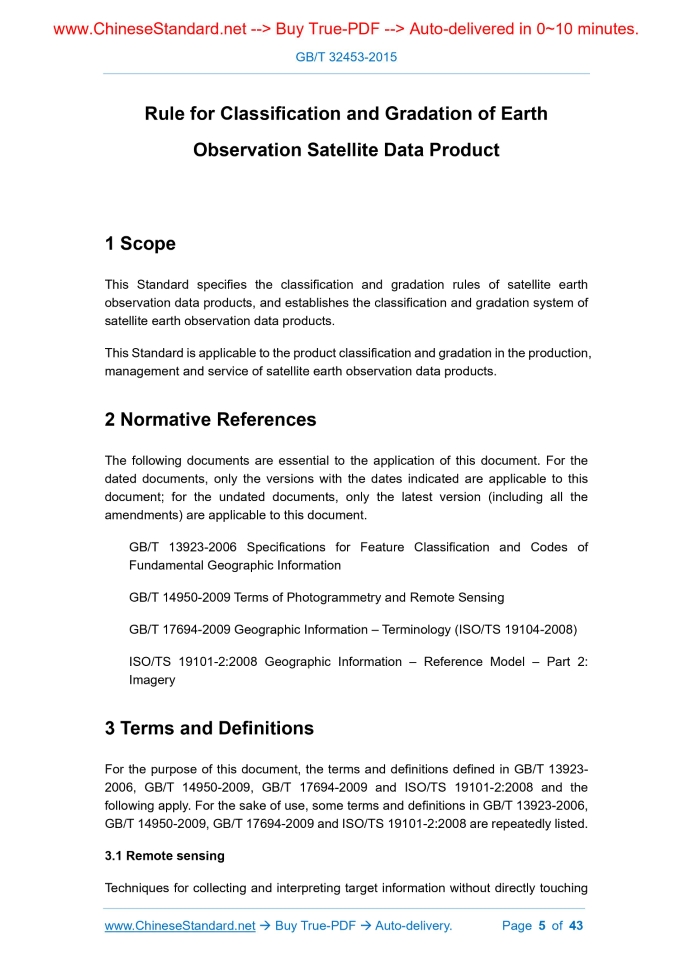
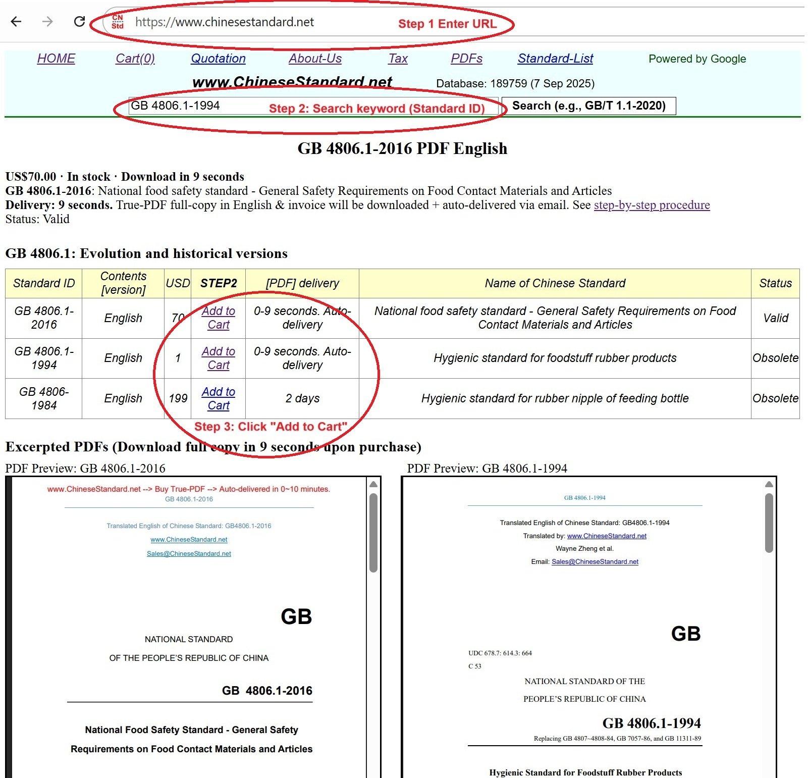
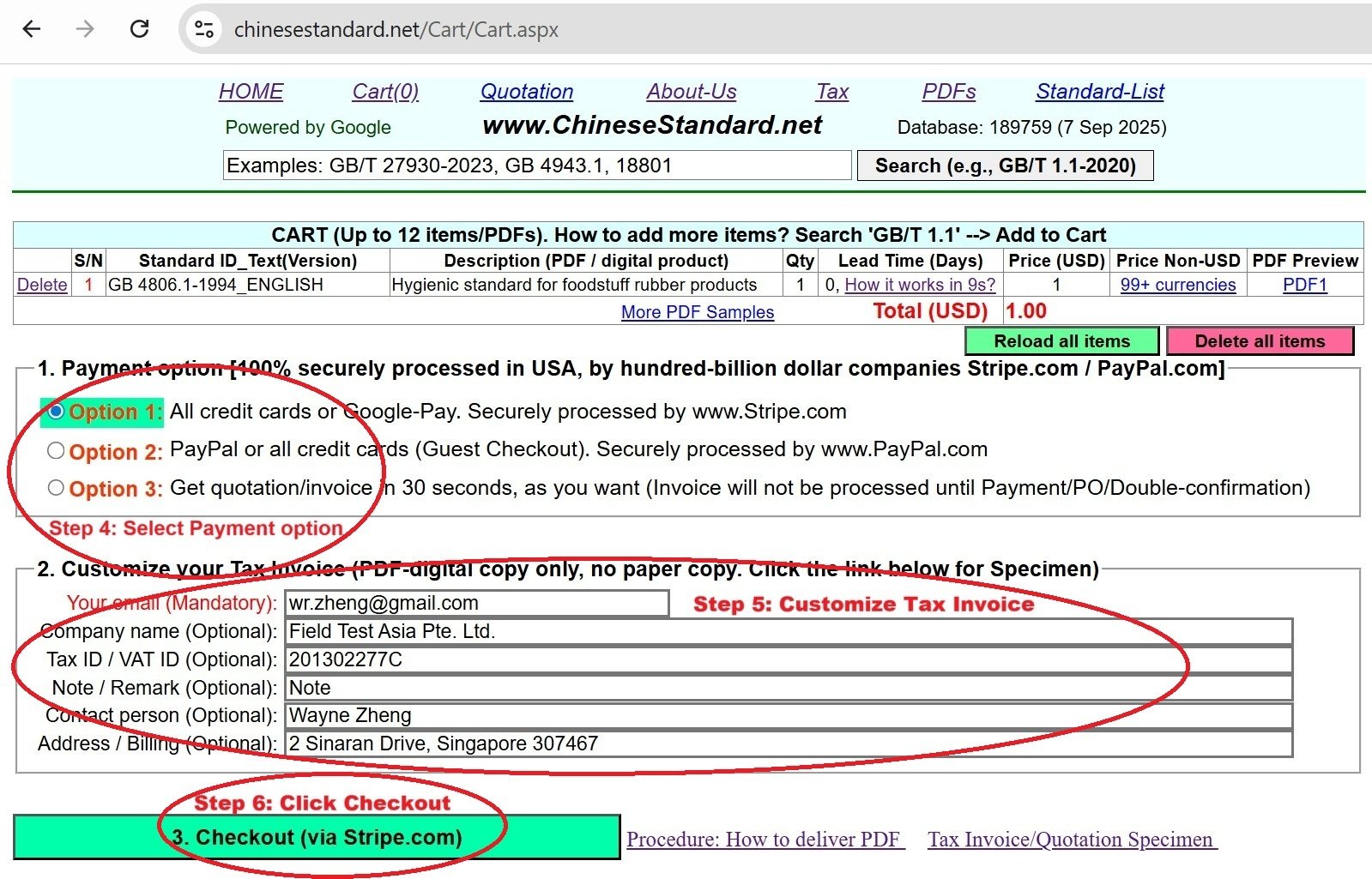
Similar standardsGB/T 32453-2015: Rule for Classification and Gradation of Earth Observation Satellite Data Product---This is an excerpt. Full copy of true-PDF in English version (including equations, symbols, images, flow-chart, tables, and figures etc.), auto-downloaded/delivered in 9 seconds, can be purchased online: https://www.ChineseStandard.net/PDF.aspx/GBT32453-2015 NATIONAL STANDARD OF THE PEOPLE’S REPUBLIC OF CHINA ICS 49.020 V 70 Rule for Classification and Gradation of Earth Observation Satellite Data Product ISSUED ON: DECEMBER 31, 2015 IMPLEMENTED ON: JULY 01, 2016 Issued by: General Administration of Quality Supervision, Inspection and Quarantine; Standardization Administration of PRC. Table of ContentsForeword ... 3 Introduction ... 4 1 Scope ... 5 2 Normative References ... 5 3 Terms and Definitions ... 5 4 Abbreviation ... 10 5 Classification and Gradation Principles ... 10 6 Classification System and Rules ... 11 6.1 Classification system ... 11 6.2 Classification rules ... 11 7 Gradation System and Rules ... 16 7.1 Gradation system ... 16 7.2 Gradation rules ... 17 8 Expansibility Principles ... 20 Appendix A (Informative) Attributes and Measurement Units of the Grading Indicators for Optical and Microwave Data Products (Partial) ... 21 Appendix B (Informative) Examples of Application for Classification and Gradation Rules of Satellite Earth Observation Data Products ... 25 Bibliography ... 42 Rule for Classification and Gradation of Earth Observation Satellite Data Product1 ScopeThis Standard specifies the classification and gradation rules of satellite earth observation data products, and establishes the classification and gradation system of satellite earth observation data products. This Standard is applicable to the product classification and gradation in the production, management and service of satellite earth observation data products.2 Normative ReferencesThe following documents are essential to the application of this document. For the dated documents, only the versions with the dates indicated are applicable to this document; for the undated documents, only the latest version (including all the amendments) are applicable to this document. GB/T 13923-2006 Specifications for Feature Classification and Codes of Fundamental Geographic Information GB/T 14950-2009 Terms of Photogrammetry and Remote Sensing GB/T 17694-2009 Geographic Information – Terminology (ISO/TS 19104-2008) ISO/TS 19101-2:2008 Geographic Information – Reference Model – Part 2: Imagery3 Terms and DefinitionsFor the purpose of this document, the terms and definitions defined in GB/T 13923- 2006, GB/T 14950-2009, GB/T 17694-2009 and ISO/TS 19101-2:2008 and the following apply. For the sake of use, some terms and definitions in GB/T 13923-2006, GB/T 14950-2009, GB/T 17694-2009 and ISO/TS 19101-2:2008 are repeatedly listed. 3.1 Remote sensing Techniques for collecting and interpreting target information without directly touching 3.9 Black body A hypothetical ideal radiator, it can absorb all the external electromagnetic radiation without any reflection and transmission. 3.10 Emissivity The ratio of the radiation emittance of an object at a certain temperature and a certain wavelength to the radiation emittance of a black body at the same temperature and the same wavelength, which is also called the specific emissivity. 3.11 Brightness temperature The temperature of the black body equal to the radiation emittance of the observed object, the value of which is equal to the radiation temperature. 3.12 Backscattering coefficient Radar reflectance per unit cross-sectional area of the target in the direction of incidence. 3.13 Digital elevation model A dataset that assigns two-dimensional coordinate elevation values through an algorithm. [GB/T 17694-2009, definition B.133] 3.14 Fundamental geographic information features Geographical elements described by basic geographic information include water systems, residential areas and facilities, transportation, pipelines, borders and political districts, landforms, vegetation and soil, place names, and the basis for spatial positioning, etc. [GB/T 13923-2006, definition 2.2] 3.15 Radiometric correction Correction of systematic and random radiation distortion or deformation caused by external factors, data acquisition and transmission systems. [GB/T 14950-2009, definition 5.195] 3.16 Relative radiometric correction Normalize the amount of radiation measured between image elements or between sensors, between spectral bands, or at different times. sources, such as edge extraction, classification, etc., and fuse at the feature layer. 3.25 Decision-level fusion Fusion based on image understanding and image recognition, that is, fusion after feature extraction and feature recognition process. 3.26 Parameter inversion Based on the model knowledge, the state parameters of the target are inferred based on the measurable parameter values, which is also known as parameter inversion. 3.27 Validation An independent method is used to evaluate the authenticity and accuracy of satellite earth observation data products. 3.28 Cross validation The use of verified satellite earth observation data products with known accuracy to evaluate the quality of satellite earth observation data products to be inspected is an indirect method of authenticity verification. 3.29 Geoelectric field The electric field that exists naturally on the earth's surface is divided into a geoelectric field and a natural electric field according to the field source. The geoelectric field refers to a geoelectric field that changes globally or regionally, and the natural electric field is a geoelectric field that changes relatively locally. 3.30 Geomagnetic field The Earth's magnetic field exists in a wide space from the Earth's core to hundreds or even thousands of Earth radius. It originates from magnetic rocks inside the Earth and current systems distributed inside and outside the Earth. It consists of three parts, including core field, crustal field and changing magnetic field. 3.31 Ionosphere The ionosphere is an area where the upper atmosphere of the earth is partially ionized above 60km. 3.32 Earth gravity field The vector field formed by the gravity vector corresponding to each point in the space domain on the surface of the earth and near the ground affected by gravity. 3.33 Gravity gradient gradation systems have a clear structure and can reflect the inherent characteristics and connections between different categories and grades of data products. 5.2 The classification and gradation rules have broad applicability; and the scope of the classification and gradation system shall cover various existing remote sensing satellite earth observation data products. 5.3 The settings and classification characteristics of categories and grades shall be concise and clear, easy to operate and accepted and used by various users. 5.4 The formulation of classification and gradation rules first considers mainstream data products that are currently widely used and highly standardized. At the same time, it shall also consider the possibility of new data products and new categories and grades in a certain period of time in the future, which shall be scalable. 5.5 It shall be able to establish a clear mapping relationship with the classification and gradation rules of earth observation data used by the remote sensing satellites at home and abroad; and can be easily integrated with relevant foreign classification and gradation schemes.6 Classification System and Rules6.1 Classification system The satellite earth observation data products are classified according to the target characteristics and detection methods detected by the satellite sensors. The classification system consists of large, medium and small categories. Products involved in the comprehensive processing of different types of satellite earth observation data products can be classified into corresponding categories according to the main data sources used. 6.2 Classification rules 6.2.1 Large categories According to the detection bands of satellite sensors and the main characteristics of their observation objects, they are divided into three categories: optical data products, microwave data products, and geophysical data products: a) Optical data products: data products with the detection wavelength range of 0.1µm ~ 1.0×103µm; with reflectance and radiation energy of the target object obtained by the optical sensor and the image data products obtained by processing them. Or image data products with distance and the like information of the target detected by the emitting laser pulses Information and processing them; According to the detection method of data acquisition, the microwave data products are divided into two medium categories: active microwave data products and passive microwave data products: a) Active microwave data products: data products obtained by detecting the backscattering characteristics or echo delay information of earth objects through transmitting microwave signals with microwave sensors; and image data products obtained by processing them; b) Passive microwave data products: data products obtained by detecting microwave radiation characteristics of the earth or the atmosphere through microwave sensors; and image data products obtained by processing them. 6.2.2.3 Geophysical field data products According to the detected geophysical field, it is divided into three medium categories: gravity field data products, electromagnetic field data products and other geophysical field data products: a) Gravity field data products: data products with earth’s gravity field obtained by satellite motion parameters by tracking each other between satellites or directly observe satellite gravity gradient inversion; b) Electromagnetic field data products: data products with the parameters such as the earth’s basic magnetic field, changing magnetic field and atmospheric, ionosphere-related electromagnetic fields and plasma obtained through observations of geoelectric fields, geomagnetic fields, and ionospheric parameters, etc.; c) Other geophysical field data products. See Table 1 for the classification system structure of satellite earth observation data products. f) Ku waveband (12GHz~18GHz); g) K waveband (18GHz~27GHz); h) Ka waveband (27GHz~40GHz); i) V waveband (40GHz~75GHz); j) W waveband (75GHz~110GHz); k) mm waveband (110GHz~300GHz). 6.2.3.2.3 According to the polarization method of microwave detection, it is divided into 6 categories, which are as follows: a) HH polarization (horizontal transmission, horizontal reception); b) VV polarization (vertical transmission, vertical reception); c) HV polarization (horizontal transmission, vertical reception); d) VH polarization (vertical transmission, horizontal reception); e) Dual polarization (HH/VV, HH/HV, VV/VH, HV/VH); f) Full polarization (HH/HV/VV/VH). 6.2.3.2.4 The small categories of spaceborne active microwave (imaging radar) data products currently include: a) HH polarized products, VV polarized products, HV polarized products, VH polarized products, dual polarized products and fully polarized products in the L waveband; HH polarized products and VV polarized products in the S waveband. b) HH polarized products, VV polarized products, HV polarized products, VH polarized products, dual polarized products and fully polarized products in C waveband. c) HH polarized products, VV polarized products, HV polarized products, VH polarized products, dual polarized products, and fully polarized products in X waveband. 6.2.3.3 Passive microwave data products 6.2.3.3.1 The passive microwave data products are divided into small categories based on two factors, i.e. the working waveband of the microwave and the polarization mode of the detection. 7.1.2 Level-0 is the original data product obtained by processing the data received by the ground station through de-formatting. 7.1.3 Level-1 and Level-2 products are basic data products commonly used in various industries and fields; and their gradation is divided according to the processing level of radiometric correction and geometric correction. 7.1.4 Levels-3~6 products are value-added data products in various industries and fields. They are data products obtained by integrating processing the ground control points or digital elevation models and thematic application information according to application requirements. 7.1.5 Level-0 and basic data products include corresponding grades of data products generated by superimposing some basic geographic information elements. 7.1.6 Sub-level data products are products that are further divided according to the single-item data processing levels on the basis of Levels-1~6 data products. 7.1.7 Extended-level data products are products further subdivided on the basis of sub- level products. 7.1.8 The content of the grading indicators and the nominal measurements adopted by different categories of satellite earth observation data products are different. For the attributes and their measurement units of the grading indicators for some optical and microwave data products can refer to Appendix A. 7.2 Gradation rules 7.2.1 Level-0 (L0) Level-0 data products refer to initial data products that have been de-formatted and decompressed for distribution by strip, scene, or region. 7.2.2 Level-1 (L1) Level-1 data products are radiation-corrected data products from Level-0 data and can be divided into 2 sub-levels according to the degree of radiometric correction processing. Sub-level 1 (L1_1): Products that have undergone the relative radiometric correction. Sub-level 2 (L1_2): Products that have undergone the absolute radiometric correction. 7.2.3 Level-2 (L2) Data products that have undergone system geometric correction based on L0-L1 data Professional application data products obtained through fusion and parameter inversion of professional data or information integration processing based on the L0- L4 data; sub-levels and extended levels can be subdivided according to the degree of processing. According to the degree of image fusion, Sub-levels 1 ~ 3 are divided. Sub-level 1 (L5_1): Data products that have undergone the pixel-level fusion. Sub-level 2 (L5_2): Data products that have undergone the feature-level fusion. Sub-level 3 (L5_3): Data products that have undergone the decision-level fusion. From the perspective of parameter inversion, Sub-levels 4 ~ 6 are divided. Sub-level 4 (L5_4): Inversion products based entirely on the parameter itself. Sub-level 5 (L5_5): Parametric inversion products verified by cross-checking method. Sub-level 6 (L5_6): Parametric inversion products that have undergone field authenticity testing. 7.2.7 Level-6 (L6) Data products that use the three-dimensional expression based on L3-L5 data. Sub-level 1 (L6_1): Unmeasurable three-dimensional expression data products produced from data products at level L3 and above. Sub-level 2 (L6_2): Measurable three-dimensional data products produced from data products at level L4 and above. Sub-level 3 (L6_3): Three-dimensional data products produced by L4 ~ L5 data products, which can support professional information analysis and process virtual expression. 7.2.8 Level Identification The level identification consists of a level identification, sub-level identification, and extended level identification. Thereof, the identification of the levels and sub-levels is represented by the combination of the letter L and Arabic numerals; and the identification is shown in Table 3. ......Source: Above contents are excerpted from the full-copy PDF -- translated/reviewed by: www.ChineseStandard.net / Wayne Zheng et al. Tips & Frequently Asked Questions:Question 1: How long will the true-PDF of English version of GB/T 32453-2015 be delivered?Answer: The full copy PDF of English version of GB/T 32453-2015 can be downloaded in 9 seconds, and it will also be emailed to you in 9 seconds (double mechanisms to ensure the delivery reliably), with PDF-invoice.Question 2: Can I share the purchased PDF of GB/T 32453-2015_English with my colleagues?Answer: Yes. The purchased PDF of GB/T 32453-2015_English will be deemed to be sold to your employer/organization who actually paid for it, including your colleagues and your employer's intranet.Question 3: Does the price include tax/VAT?Answer: Yes. Our tax invoice, downloaded/delivered in 9 seconds, includes all tax/VAT and complies with 100+ countries' tax regulations (tax exempted in 100+ countries) -- See Avoidance of Double Taxation Agreements (DTAs): List of DTAs signed between Singapore and 100+ countriesQuestion 4: Do you accept my currency other than USD?Answer: Yes. www.ChineseStandard.us -- GB/T 32453-2015 -- Click this link and select your country/currency to pay, the exact amount in your currency will be printed on the invoice. Full PDF will also be downloaded/emailed in 9 seconds.How to buy and download a true PDF of English version of GB/T 32453-2015?A step-by-step guide to download PDF of GB/T 32453-2015_EnglishStep 1: Visit website https://www.ChineseStandard.net (Pay in USD), or https://www.ChineseStandard.us (Pay in any currencies such as Euro, KRW, JPY, AUD).Step 2: Search keyword "GB/T 32453-2015". Step 3: Click "Add to Cart". If multiple PDFs are required, repeat steps 2 and 3 to add up to 12 PDFs to cart. Step 4: Select payment option (Via payment agents Stripe or PayPal). Step 5: Customize Tax Invoice -- Fill up your email etc. Step 6: Click "Checkout". Step 7: Make payment by credit card, PayPal, Google Pay etc. After the payment is completed and in 9 seconds, you will receive 2 emails attached with the purchased PDFs and PDF-invoice, respectively. Step 8: Optional -- Go to download PDF. Step 9: Optional -- Click Open/Download PDF to download PDFs and invoice. See screenshots for above steps: Steps 1~3 Steps 4~6 Step 7 Step 8 Step 9 |